Historic Places And Monuments
Scupi is one of the largest Roman cities in the Balkans with the status of a colony. It is situated 5 km northwest of Skopje, near Zlokukani, on the southwest slope of Zajčev Rid, left of the site where the river Lepenec flows into the Vardar. Its precise location was identified by Arthur Evans in 1883. Continuity of life on this site has been confirmed from the Bronze and Iron Ages to the 6th century B C. The beginnings of this city are linked with the incursions of the Roman legions in the late 1st century BC and the founding of the province of Moesia in 15 AD.
The question concerning its previous status, i.e., whether it was a civilian settlement or a legion camp, remains open. During the Flavian dynasty, probably during the reign of Domitian, in 84/5 it acquired the status of a self-governing deductive colony ( Colonia Flavia Scupinorum) with the settling of veterans, mainly those from Legio VII Claudia.
The original settlement was transformed into a complex Roman urban city with all the administrative, civilian and religious facilities and structures which the new conditions and circumstances required. It developed as an important administrative, economic, cultural, religious and transit center of the province Moesia Superior.
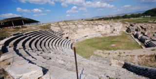
There is a reference to Stobi in Ptolemy in the 2nd century. During Marcus Aurelius, in 170, the Dacian Costoboci passed through it during their incursions towards Aegea. In 268/69 it was ravaged by the fierce hordes of Goths and Heruls/ Eruli. In the late 3rd century it became the metropolis of the newly established province of Dardania, and in the 4th century, it experienced once again great economic and urban growth. In the Tabula Peutingeriana (4th century) it is marked with a vignette as the province capital. During his stay in Stobi in 379 and 388, Emperor Theodosius I issued two imperial edicts. The city was probably not spared during the ravaging incursions of the Huns in 447. Between the 4th and 6th centuries, it was an episcopal and metropolitan see. In 518 it was destroyed in a disastrous earthquake recorded in the Chronicle of Marcellinus Comes. After the renewal in the 6th century, urban life eventually ceased towards the end of the century, during Mauricius (582/3). It survived as a small rural settlement until the 10th and 11th centuries. Its urban features, the infrastructure and the high level of The surrounding walls are in the form of an irregular rectangle (738 x 590 m), covering a surface of 43 hectares. The city plan has an orthogonal design. The streets, paved with massive stone slabs, run parallel with the rampart walls (SW/NE/NW/SE) and intersect at a right angle. The pavements are separated with curbs and are covered with porticos. Under and by the streets there is a sewage system for waste water, as well as a complex grid of clay and lead pipes for the supply of clear water. Throughout its historical development, the city preserved its basic urban plan, with the same orientation of the building complexes and other structures, despite the fact that the dimensions and purpose of the city quarters changed in different periods. In terms of its urban design, judging from the scope of its exploration, these urban features are especially characteristic of the Late Antique Period (late 3rd and the 4th centuries.) Several building complexes and structures have been completely or partially explored: the theater (a grandiose structure with the unearthed contours of the skena, the theater building and the auditorium, with luxurious architectural marble decoration) which belongs to the Roman type of theaters, built during Hadrian in the 2nd century; a horeum (a large-size public building which served as a warehouse, built between the late 3rd and early 4th centuries); a city villa/domus (a private house with walls resplendently decorated with frescoes and private floor heating, built between the 3rd and 4th centuries); a civilian basilica (a representative and monumental public building with lavish architectural marble decoration and a mosaic floor, built in the 4th century); a city bath (a public building with floor heating and sections for hot and cold baths, built in the period between the 4th and 5th centuries); a three-nave Early Christian basilica with a baptistery on the south side, dating from the period between the 5th and 6th centuries); a small housing complex (private houses from the 6th century); several structures of unidentified purpose and part of the street grid ( the cardo maximus, a crossroads with two decumani, another cardo and a decumanus from the period between 4th and 6th centuries). The necropolises and other auxiliary buildings are outside the city walls. Approximately 1,000 graves from the southeast and northwest necropolises have been explored, which date from the period between the 1st and the 4th centuries, as well as parts of the Antique bridge across the river Vardar, a private villa and a Christian basilica in the village of Bardovci.
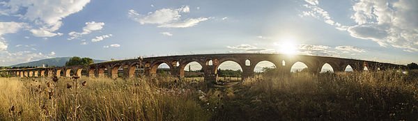
The Skopje Aqueduct is an archaeological site located 2 km north-west of Skopje, Republic of Macedonia. The Skopje Aqueduct is the only aqueduct in Macedonia, and one of three in the former Yugoslavia. It is unclear when it was made. One theory suggests it was built by the Romans. But it may only have been constructed as recently as the 16th century, by the Turkish. Under the Ottoman Empire it provided water for public baths. Today, 55 stone arches of the Skopje Aqueduct remain standing.
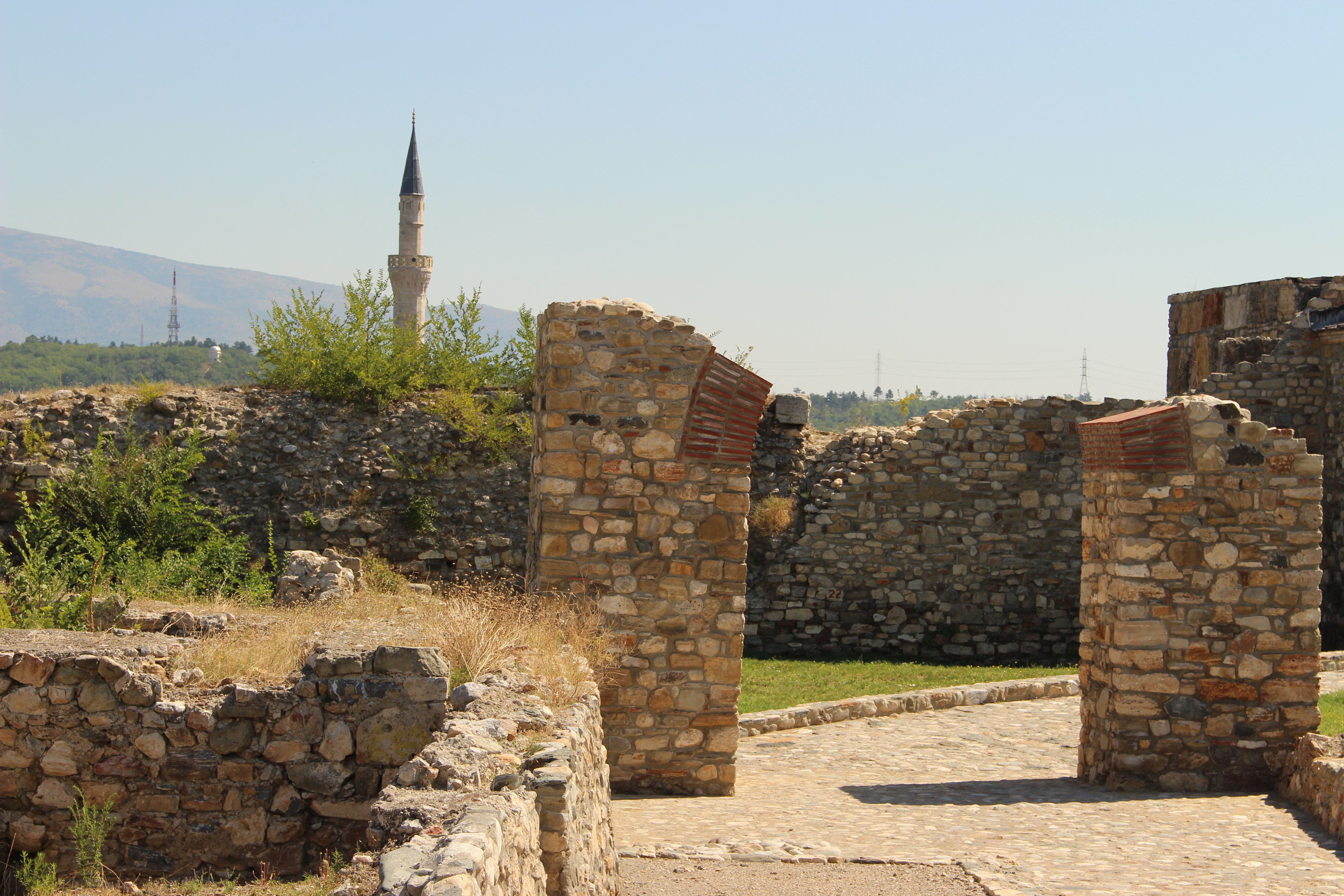 The Skopje Fortress –Kale holds the most prominent position in the central area of the city of Skopje. It stands on the long ridge of sediment sandstone that stretches along the east bank of the Vardar in the N/S direction, on its southern, most prominent part. The entire cultural and political history of the city is practically linked with this area. It was inhabited as a settlement as early as in prehistoric times, more specifically, in the Eneolithic Age. Beginning with this, the earliest settlement, and through certain periods in the Bronze and the Iron Age, the intensity of the settlement of this area varied, until the time prior to the establishment of the Roman government in Macedonia.
However, this area was settled with highest intensity as a mediaeval fortress, more precisely, as the Upper Town of the mediaeval Skopje. As such, it was reconstructed in the periods that followed, at the time of the Ottoman conquest, and remains in use to the present day. In prehistoric times, there were at least three settlements (Eneolithic, Bronze Age, Iron Age), while in the Middle Ages and the Ottoman period, at lest three other settlements were consecutively built (the first between the 10th and 13th or 14th centuries, the second between the 14th and 17th centuries and the third between the 18th and 20th centuries).
The earliest finds from the Skopje Fortress are the remains of the very first settlement from the Copper Age ( Eneolithic) or the 4th millennium B C. Various structures, mud huts or semi-mud huts which served as dwellings, cult structures or waste or storage pits were dug into clay subsoil. In the next period, the Bronze Age, i.e., during the 3rd and 2nd millennia B C, prehistoric way of life continued, this time in a smaller area, limited mainly to the northeast parts of the Fortress. In addition to numerous movable finds and remains of dwelling structures, ceramic ware kilns and other remains of material culture from all the stages of the Bronze Age have also been recorded in these strata.
In the course of the 13th century, life in Skopje’s Upper Town continued with the same intensity. The ramparts were reconstructed and surrounded an entirely new urban area, while the city was further fortified with surrounding walls and the so-called Lower Town (suburbium). A church with a cross-shaped interior and a necropolis around it was discovered on the highest and most dominant part of the Fortress, in the southeast part of the city. According to written records, other churches stood there as well, inside the Skopje Fortress, dated to the same period. In 1391, Skopje was captured by the Ottomans, who destroyed the city and parts of the city ramparts. After these events, the Fortress was used for other purposes and served as a military barracks. The buildings and the entire cultural inventory that have been discovered and which are dated to this period reflect activities customary for a fortress that served this purpose.
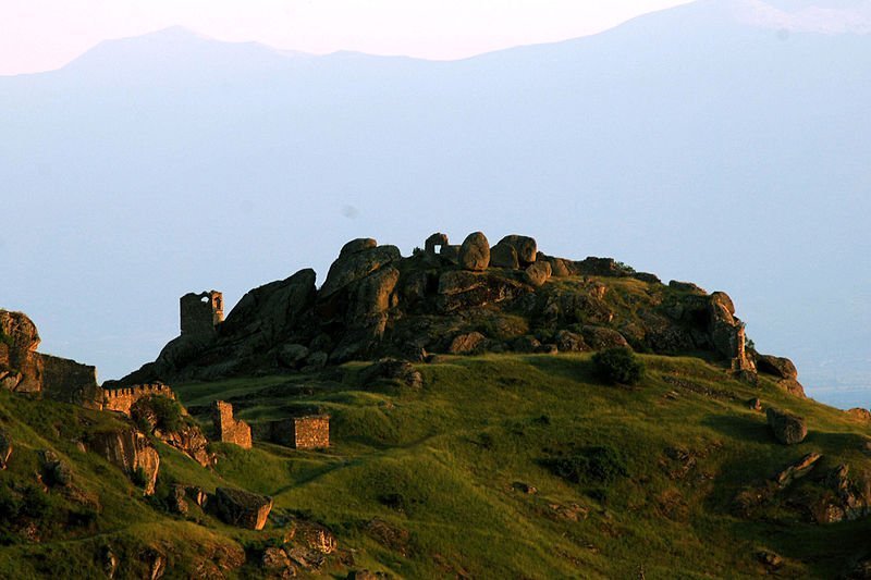
The site of Markovi Kuli, the most visible remnant among the mediaeval monuments in the Republic of Macedonia, stands on the granite rocks on the north periphery of the city of Prilep, above the suburbium of Varoš. Markovi Kuli and its suburbium Varoš were an important mediaeval social, economic and cultural centre whose historical development can be traced through the material evidence and historical records. The fortress and the name of Prilep are first mentioned in written historical records in the short history by Iona Skilica and in the sigillions of the Byzantine Emperor Basil II in the early 11th century. The first archaeological explorations of Markovi Kuli and its suburbium, as well as of the area of the present-day settlement of Varoš began in 1958; these excavations revealed that this site was settled without interruptions over an extended period of time. Remains from the cultural strata from the Late Neolithic to the 19th century have been discovered on the granite rocks of Markovi Kuli, its suburbium and Varoš. The most impressive material evidence from the mediaeval period on this site are the remains of the three rampart walls that surrounded the fortress of Markovi Kuli, the structure with which the present-day city of Prilep is identified and whose hallmark it has become.
After the fall of Samoil’s state, in the 11th century and in the first half of the 12th century, the settlement from Markovi Kuli was relocated at the foot of the massif and to Varoš, in the area of and around the churches of St. Nicholas, St. Demetrius and St. Athanasius. From the middle of the 12th century, under the influence of Byzantine style of building, in the settlement under Markovi Kuli, the builders began to use stone, brick and sun-dried brick, with clay and lime mortar used as binding materials. In the period between the 12th and 14th centuries, feudal castles were built on its west and south terraces. Among these structures, one unit has been explored, with remnants of a residential and an auxiliary building, a stable , a blacksmith’s workshop and a castle chapel. The 12th and especially the 13th and 14th centuries are characterized by intensive building of sacral structures. In the area of the mediaeval Prilep and Varoš, several churches were built which testify to the fact that the city under Markovi Kuli was an important spiritual centre in Macedonia. Markovi Kuli, the spacious terraces of its suburbium and the settlement of Varoš reflect the life in the prominent mediaeval city of Prilep which reached its full bloom in the second half of the 13th century and the first half of the 14th century. After the death of King Marko in the late 14th century, the life in the city under Markovi Kuli gradually ceased, and a new settlement was formed on the plain on the northeast edge of the Pelagonija Valley.
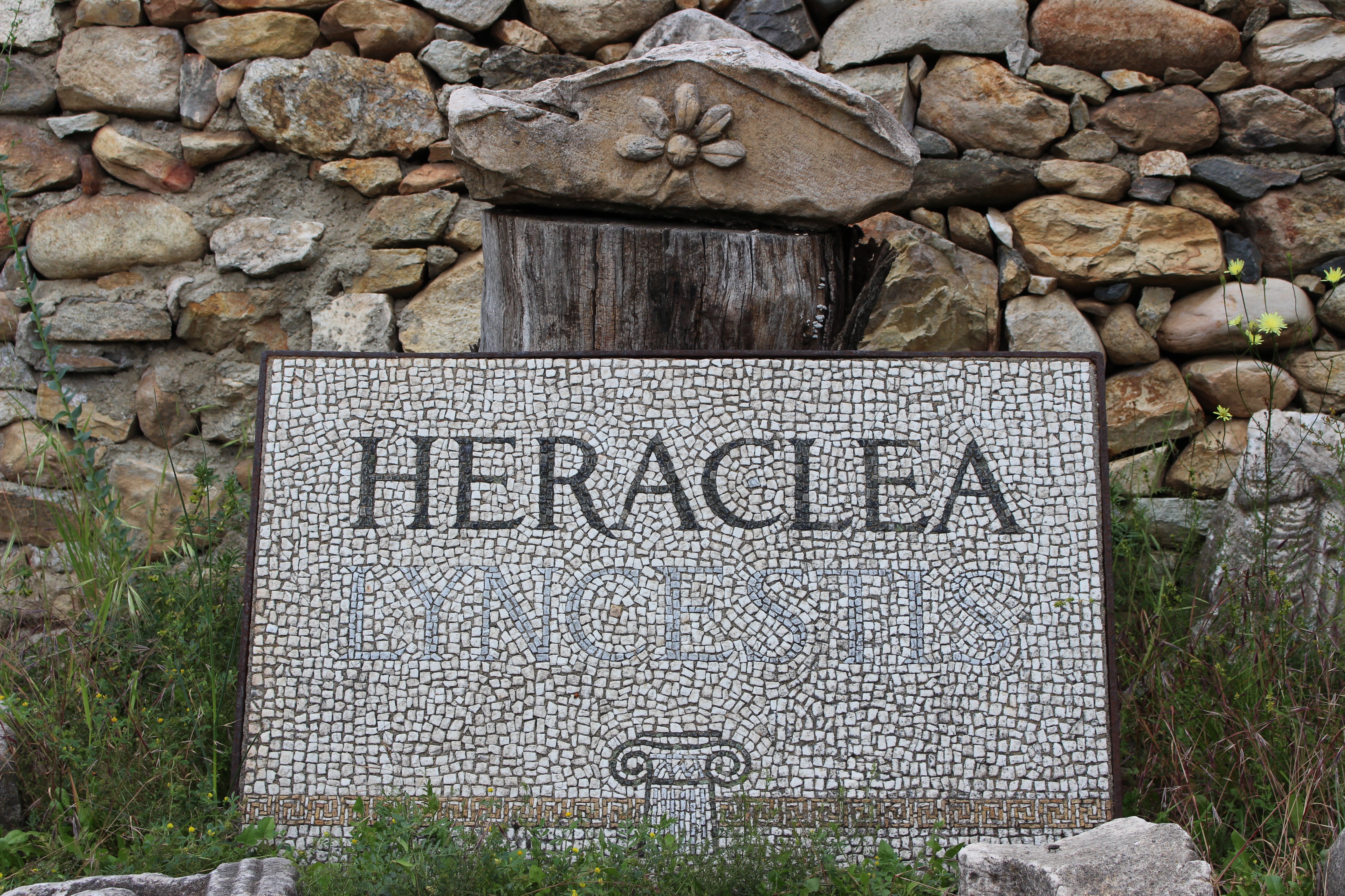
The Antique city of Heraclea Lyncestis is situated on the south side of the city of Bitola, in its immediate vicinity. The antique ruins of Heraclea provoked scholarly interest in the early 19th century. Diplomatic representatives were especially active in this domain, and this site was an important part of their daily activity. The favourable geographic features and historical circumstances contributed to the superiority of Heraclea during the Antique period. The city lies in a fertile plain, in the ancient region of Lyncestis, protected from the north by Mt. Baba and the small river Siva Voda on the south. From time immemorial, a road (known as the road of Candavia) led through it which, during the Roman period, substituted the most famous road of the classical epoch, the Via Egnatia that linked the Adriatic and Aegean coasts. It was recorded as an important stop in a number of itineraria, such as Itinerarium Antonini and Itinerarium Birdigalense, while in Tabula Peutingeriana and the anonymous geographer of Ravenna refers to it as a stop on the road Heraclea-Stobi. The emergence of this, the most important city in Antique Macedonia, is linked with the name of Philip II of Macedonia, in mid-4th century B C . Towards the middle of the 2nd century, the Romans conquered Macedonia and subdued its political power, turning it into a province and partitioning it into four regions. Despite such a situation, Heraclea, which became part of the fourth region, experienced a degree of prosperity. In the first three centuries of the new era, it acquired the status of a Roman colony. This is confirmed by an inscription on a marble base dating from the 3rd century AD, which includes a reference to the name of Septimia Aurelia Heraclea. In terms of its physiognomy in the Roman period, several structures from the 2nd century AD have been discovered that convey the spirit of the times: the Thermae, the Portico of the Court House with an impressive framed inscription from Hesiod’s Works and Days, and the ingenious feat of Roman architecture, the Theatre, where the strict construction rules of Vitruvius are incorporated to perfection. It is a relatively small structure (twenty rows of seats) which could take in 2,500 spectators, with the Nemesion above the uppermost row. Heraclea experienced its most glorious period and flourishing when it stepped on the path of the cross and became a prominent Episcopal See. The reference to the bishops ( Eugarius, Quintilius and Benignus from the period between the 4th and 6th centuries AD) and their participation in the church councils, as well as the ensemble of the unique architectural achievements, the Small Basilica, the Great Basilica, the Episcopal Residence and the City Fountain built by Bishop John on the occasion of the 35th anniversary of the reign of the energetic Emperor Justinian clearly testify to this fact. Perhaps the most mystifying and most impressive feature of Heraclea are the floor mosaics done in a variety of techniques (tessalatum and sectile), which cover the surface of ca. 1,300 m2. All the mosaics in Heraclea possess unique beauty, but the masterpiece of Early Christian art is the floor mosaic in the narthex of the Great Basilica. It is a genuine testimony to the Christian faith; in its symbolic language we can identify the ancient alphabet of the Christian religious system. The city of Heraclea did not enjoy long the fruits of its Golden Age. The dark age of barbarism came about with the onslaughts of Avars and Slavs. They did not settle it, but scattered around it and interrupted forever the city’s urban life that had gathered all kinds of experiences over the centuries.

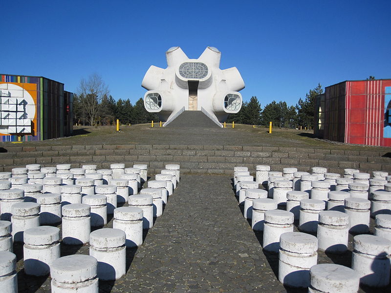
Makedonium is a monument in Kruševo, Republic of Macedonia. It was officially opened on August 2 of 1974, on the 30th anniversary of the Second Session of the Anti-fascist Assembly for the National Liberation of Macedonia and the 71st anniversary of Ilinden uprising.
It is dedicated to all the fighters and revolutionaries who participated in the Ilinden uprising of 1903, as well as soldiers-partisans of the Macedonia National Liberation Struggle 1941-1944.
The monument grounds cover 12 acres. The building has a rounded shape with protruding oval windows. The upper windows are made of stained glass.
Inside the dome is the tomb of Nikola Karev, president of the Kruševo Republic, and the bust of the singer Toše Proeski. The interior of the dome has four windows, each facing a different direction including the locations associated with the Ilinden-related events ″Sliva″ Memorial, Bear stone and Pelagonija.
The memorial complex also features a plateau with series of sculptures named “Breaking the Chains”, symbolizing freedom won in the liberation wars. There is also a crypt with the carved names and important events related to the period before, during and after the Ilinden uprising. The last component is the amphitheater decorated with colorful mosaics.
During the Macedonian-Hellenistic period in world history (from the late 4th to the 1st centuries B C), Lychnidos was a wealthy urbanized city on the shores of White Lake (Lake Lychnidos), near the famous Antique main road Via Egnatia. The necropolis at Deboj (the smaller east side of Ohrid Hill) and at Gorna Porta ( Upper Gate, north entrance in the old part of Ohrid) explored in 1978/1979 and from 2000 to 2002, yielded numerous archaeological artifacts made of gold, silver, bronze and ceramics, today housed as part of the gold collection in the Robevci Museum in Ohrid.
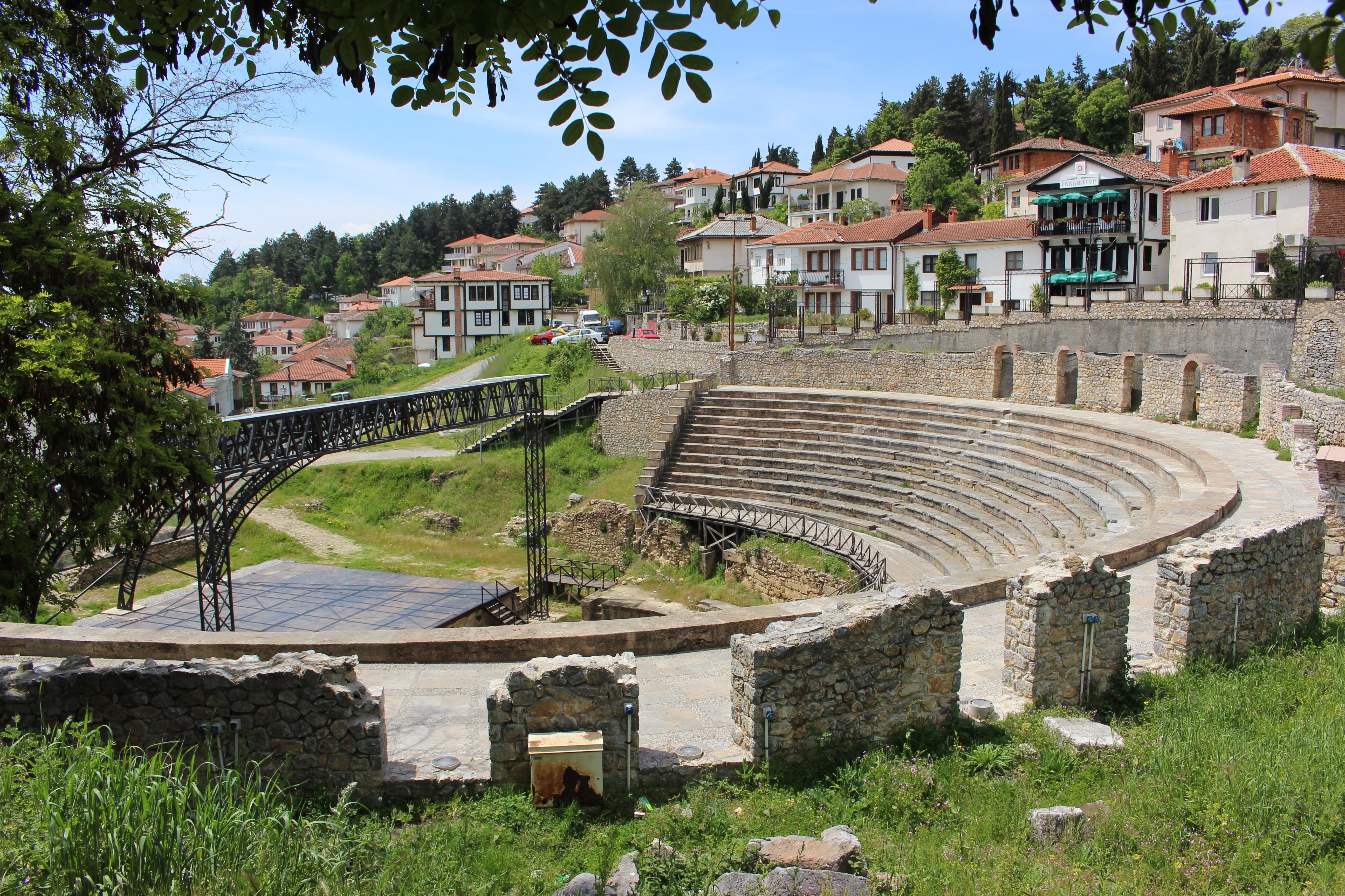
The Antique Theatre, which dates from the same period, is situated at the east foot of the higher part of Ohrid Hill, near Gorna Porta; it was probably built in the 2nd century BC and adapted in the 2nd century AD to meet the needs of the Roman society. Today, explored, conserved and presented to the public, it is used for spectacular performances which are part of the cultural life of Ohrid and Macedonia. West of the theatre, in its immediate vicinity, a typical ancient Macedonian tomb is fully preserved, with steps leading to the entrance, a dromos, an antechamber and a chamber, which stood in this old part of Ohrid in the late 4th or early 3rd century B C. The first references to the city of Lychnidos and the fortress come from the Antique historian Livius in 209 B C, during the reign of the Macedonian king Philip V. This testifies to the fact that in the late 3rd century B C the fortress had already served its purpose in all the decisive moments in the history of the city of Lychnidos, the present-day Ohrid.